
Millions of people have visited Hadrian's Wall, but few stop to wonder why the Romans chose its exact path across northern England. While it may appear to cut a straight line between the River Tyne and the Solway Firth, the famous frontier was anything but random. The route was carefully selected to take advantage of the North East's unique landscape, making it easier to defend while reducing the amount of work needed to build one of Britain's greatest engineering achievements.
Stretching 73 miles from Wallsend, near Newcastle, to Bowness-on-Solway, Hadrian's Wall has stood as one of Britain's most recognisable landmarks for almost 1,900 years. Built on the orders of Emperor Hadrian from AD 122, it remained the north-west frontier of the Roman Empire for nearly three centuries and became a UNESCO World Heritage Site in 1987.
The landscape did much of the defensive work.
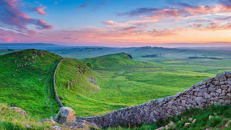
One of the biggest reasons the wall follows its famous route is the Whin Sill, a vast ridge of hard volcanic dolerite stretching across Northumberland. Instead of constructing long sections over flat ground, Roman engineers placed much of the central wall directly on top of these dramatic crags, including the spectacular stretches around Housesteads, Sewingshields and Winshields.
The steep cliffs created natural barriers that made it much harder for anyone approaching from the north. This meant the Romans could build a shorter wall with greater defensive strength while giving soldiers commanding views across the surrounding countryside. Some of the highest surviving sections of the wall still stand on these rocky outcrops today.
The route connected important Roman settlements.
The wall was not built in isolation. Before construction began, the Romans already controlled an important military road known as the Stanegate, linking forts including Corbridge and Carlisle. By following a nearby route, Hadrian's Wall allowed existing forts, roads and supply lines to work together as one coordinated frontier.
Along its length, the Romans built around 80 milecastles, two turrets between each milecastle and numerous forts, allowing soldiers to patrol efficiently while controlling movement across the frontier. The result was a sophisticated military system rather than simply a stone barrier.
Newcastle became the eastern gateway.
Although the most photographed sections lie in rural Northumberland, the eastern end begins in modern-day Wallsend, where the Roman fort of Segedunum overlooked the River Tyne. This location gave the Romans access to shipping, trade and supplies while protecting an important crossing point.
Today, Newcastle remains one of the best starting points for visitors walking Hadrian's Wall Path, with thousands travelling the full coast-to-coast route each year. The combination of Roman history and North East scenery continues to attract visitors from around the world.
A route that still makes perfect sense.
Looking at modern maps, it becomes clear that Hadrian's Wall was never intended to be the shortest route. Instead, it followed the smartest one. By using high ground, natural rock formations and existing transport links, Roman engineers created a frontier that balanced defence, efficiency and practicality.
Nearly 1,900 years later, the route still showcases the remarkable skill of Roman planners. Whether standing on the rugged Whin Sill near Housesteads or visiting Segedunum in Wallsend, it is easy to see why the North East became the ideal location for one of history's greatest engineering projects. The landscape that protected Roman Britain continues to define one of the region's most iconic attractions.
Share your experiences below.
Have you walked Hadrian's Wall or visited one of its famous forts?
Newcastle History
The North East's Greatest Roman Mystery
Advertisement

Comments (0)
You must be logged in to post comments.
Don't have an account? Register here
No comments yet. Be the first to share your thoughts!